地理空间大模型:为数字生态文明注入智慧“引擎”
Geospatial Foundation Models: Injecting Wisdom "Engines" into Digital Ecological Civilization
导读 / Abstract: 随着人工智能和地理空间数据技术的快速发展,地理空间大模型正成为支撑数字生态文明建设的核心引擎。由张继贤研究员团队发布的“莫干·玄衍”地理空间大模型,通过深度学习和智能推理,有望打破数据孤岛,提升全球生态环境治理的科学性与精细化水平。
中国将生态文明建设确立为国家战略,将“人与自然和谐共生”作为现代化目标。在数字时代,这一愿景正转化为“数字生态文明”范式,强调利用AI、大数据等技术提升治理效能。这不仅提升了本国治理能力,也为全球落实联合国2030可持续发展目标(SDGs)贡献了中国智慧。
China has established ecological civilization as a national strategy. In the digital age, this vision is transforming into a "digital ecological civilization" paradigm, emphasizing the use of AI and big data to improve governance efficiency, contributing Chinese wisdom to the global implementation of UN SDGs.
传统地理信息技术长期受限于“数据孤岛”和分析破碎化。新一代地理空间大模型(如“莫干·玄衍”)以深度学习和智能推理为驱动,能够高效整合海量异构时空数据。其变革性价值在于提供统一、自适应的智能解决方案,成为高水平生态治理的核心引擎。
Traditional GIS has long been limited by "data silos". New generation geospatial foundation models, driven by deep learning, can efficiently integrate massive heterogeneous spatiotemporal data, providing adaptive intelligent solutions for high-level ecological governance.
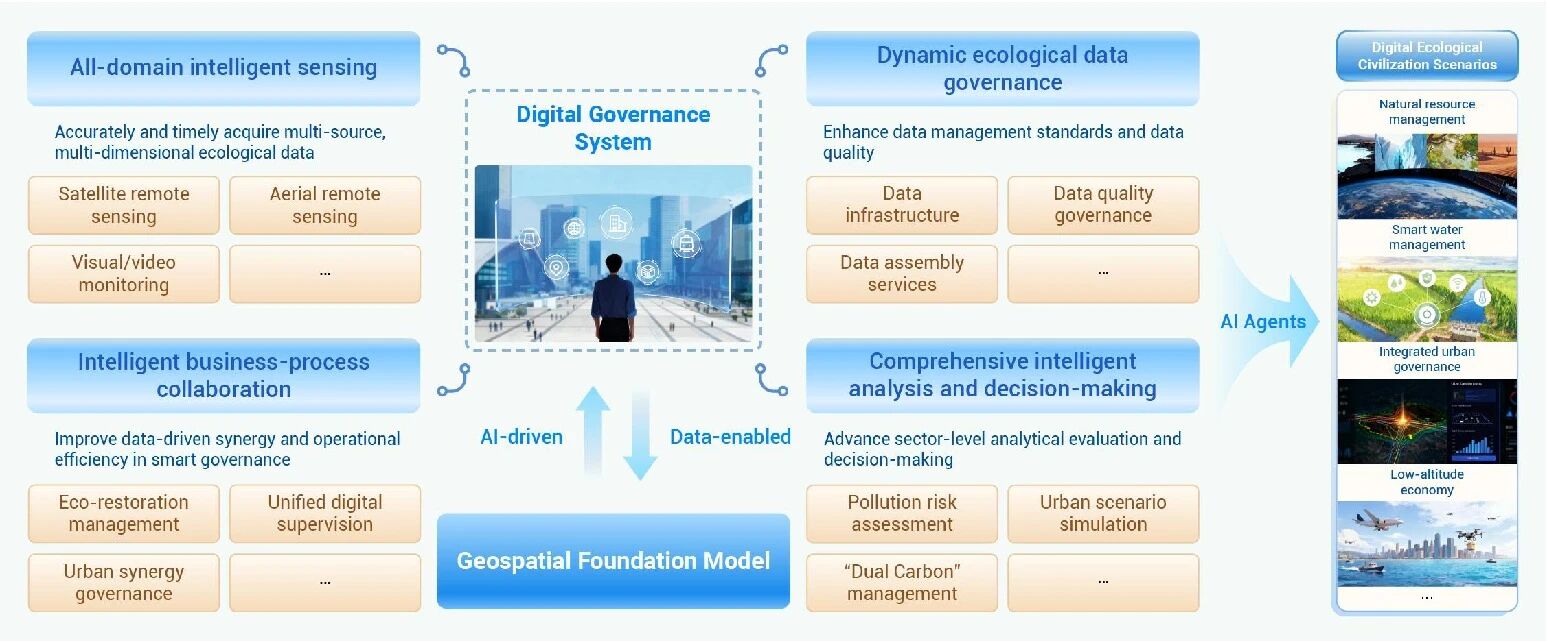
图1:地理空间大模型赋能数字生态文明建设示意图
- 全域智能感知 (All-domain Sensing): 融合卫星遥感、航空观测与地面监测,实现生态要素的立体、动态精准感知。
- 动态数据治理 (Dynamic Data Governance): 建立数据集成与质量控制机制,提升大规模生态数据的可靠性与时效性。
- 综合智能分析 (Comprehensive AI Analysis): 依托AI建模与推理,在复杂生态场景下支撑科学决策,如污染预警、资源优化配置等。
地理空间大模型与场景智能体的结合,正通过数据驱动、智能化和自适应治理方式,重塑数字生态文明的发展格局。对于 **RESIL FARM** 项目而言,这不仅是技术工具的升级,更是研究范式的变革:
The combination of geospatial foundation models and AI agents is reshaping digital ecological civilization. For the RESIL FARM project, this is not just a technical upgrade but a paradigm shift:
-
强化“现状调查-动态监测-评价优化”一体化体系: 地理空间大模型能够高效整合欧、非、中亚等全球典型区的异构监测数据,解决传统方法在跨区域尺度下的技术适配性问题。
Enhancing the integrated technology system by efficiently integrating heterogeneous data from global demonstration zones (Europe, Africa, Central Asia). -
驱动“稳产-固碳”评价智能化: 利用大模型的深度学习能力,可以更精准地识别农田基础设施与作物种植结构对气候韧性的贡献,打破传统“高产导向”的局限性。
Driving intelligent evaluation of yield stability and carbon sequestration by identifying the link between infrastructure and resilience. -
构建自适应的农田治理智能体: 通过引入 AI Agents 架构,项目能够实时响应极端气候冲击,为粮食短缺地区提供动态的智能决策建议,填补全球农田治理领域的标准空白。
Building adaptive AI agents to respond to climate shocks and provide dynamic decision support for food-deficient regions.
展望未来,RESIL FARM 将积极拥抱地理空间大模型等前沿技术,深化国际协作网络,为推动全球农业气候治理学科发展提供核心支撑。
Looking forward, RESIL FARM will embrace geospatial AI to deepen international collaboration and provide core support for global agricultural climate governance.